Information regarding a number of new Trimble products was released today at the InterGeo 2011 Conference in Nuremberg, Germany. Here's a quick look at the new technology coming your way:
Trimble S6 Robotic Total Station with Trimble VISION Technology
Now available with Trimble VISION technology, the Trimble S6 Total Station enables surveyors to remotely see and measure through a live video feed from the instrument on their data controller. By integrating survey data with the live video, surveyors can verify their work and ensure that they have captured everything before leaving the job. The calibrated camera allows users to easily integrate images into their survey workflows. Photo documentation also allows surveyors to complement the data they provide to clients with images of the job conditions and point attributes, making the data easier to understand.
The Trimble S6 Total Station continues to provide surveyors with power and flexibility. It includes the long-range EDM performance of Trimble DR Plus technology, making it capable of direct reflex measurements at more than double the range of previous models. Longer range means fewer instrument set-ups and easier access to more locations, saving surveyors time and money.
Trimble M3 Total Station with Trimble Access Field Software
The power of Trimble Access Field Software is now available on the Trimble M3 Mechanical Total Stations. Trimble Access software offers surveyors a new approach to surveying that expedites data collection, processing, analysis, and delivery through improved workflows, collaboration and control. Designed to support the surveyors� everyday work, including topographic surveys, staking, control and more, Trimble Access offers a familiar, easy-to-use interface to ensure a short learning-curve.
Trimble Access on the Trimble M3 allows surveyors the optional availability of Trimble Access Roads module. The Trimble Access Roads module imports road definitions from many third-party sources, allowing users to key in a complete road definition including horizontal and vertical alignments, templates and superelevation, and widening records. Users are guided through fast offsets, slope staking, real-time redesign and real-time quality control.
T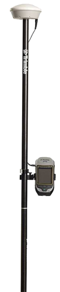 rimble GeoExplorer GeoXR Network Rover
The new rugged Trimble GeoExplorer GeoXR Network Rover is a purpose-built complete solution designed to make both high-accuracy surveying and handheld point measurement easier, more efficient and more flexible. The Trimble GeoXR Network Rover adds a new aspect to Global Navigation Satellite System (GNSS) surveying productivity by combining the functionality for high-accuracy field work with the flexibility and convenience of handheld positioning in one device.
The Trimble GeoXR can be used mounted on a survey rod with an external antenna for survey-grade accuracy and when connected to a Trimble VRS™ network, it serves as an advanced and highly productive rover. The receiver can be quickly removed from the rod and seamlessly switched to its integrated antenna—converting to a solution for handheld point measurement with easy access to features such as the integrated camera.
For GIS users, the Trimble GeoXH™ will also be offered in a centimeter-accurate configuration. With the Trimble GeoXH centimeter option, users can collect data in the field using Trimble TerraSync® Centimeter edition software for streamlined GIS workflows. The Centimeter option will be available as a paid service upgrade from the standard, 6000 series GeoXH.
Trimble Business Center Software Version 2.60
Trimble Business Center Software is a complete surveying office suite designed to manage, analyze and process all field survey data, including data from optical instruments (total stations and levels), GPS/GNSS and spatial stations (imaging and 3D scanning data).
Version 2.60 advances the capabilities of surveying offices with key new functionality, including:
- Stake-out Points Import - users can import stakeout points collected by Trimble Access Field Software. Office surveyors are able to easily validate the results for points, surfaces, and corridors that were staked in the field. The surveyor can ensure that the field-work conforms to specified criteria, create reports to deliver to clients, and archive all of the information for future needs.
- GPSeismic Export - users can export surveyed points to Trimbleï's newly acquired GPSeismic application. This export function solidifies the integration of seismic surveying workflows that go from field data collection, to office processing, to the powerful analysis tools contained in GPSeismic.
- Enhanced Baseline Processing - users can post-process GNSS observables faster by taking advantage of multi-core computer processing. By decreasing the time it takes to process baselines, the software enables office surveyors to spend more time analyzing results and creating deliverables.
Trimble Access Software Development Kit (SDK)
Software developers can now create tailored applications for customers and make them available for sale through the Trimble store. Trimble Access is a preferred field software platform for surveyors to control instruments and collect data more efficiently. A variety of specialized modules, developed by Trimble, are already available such as Roads, Tunnels, Monitoring and Mines. Tailoring workflows for the users' applications can enable a higher quality control process and more efficient workflows for field teams.
Trimble Access is a field and office solution for surveyors that expedites data collection, processing, analysis, and project information delivery through improved workflows, collaboration and control, which is enabled by wireless connectivity between the project team members. The complete solution speeds both typical and specialized surveying tasks, and enables easy, fast and secure two-way information sharing between the field survey crew and the office. Surveys can be completed faster with less time spent traveling back and forth to the office. Management and field crews can closely collaborate by viewing the same information in near real-time. With Trimble Access, productivity and efficiency can be significantly improved on projects. The four components of the Trimble Access solution include: Trimble Access services, base software for typical survey applications, specialized application modules, and the Trimble Connected Community.
Trimble's Connected Site Solutions
Trimble's Connected Site solutions for surveyors create seamless working relationships among Trimble products, technologies and services. Through the Connected Site, Trimble is focused on providing solutions that address the customers� full work processes. By carefully combining technology innovation with a deep understanding of the users' workflows, data integration and maintenance across the lifecycle of projects, Trimble helps surveyors reach new levels of productivity for their businesses.
Availability
The Trimble S6 Total Station with Trimble VISION Technology, Trimble Business Center Software version 2.60 and the Access Field Software SDK are available now. The Trimble M3 Total Station with Trimble Access Field Software and the Trimble GeoExplorer GeoXR Network Rover are expected to be available in the fourth quarter of 2011.
To learn more about these products, or to schedule a field demonstration, click here and we will have the appropriate product specialist contact you directly.
 The California Surveying & Drafting Supply (CSDS) headquarters located at 4733 Auburn Blvd. in Sacramento, California is a location well-known to members of the AEC community. For 25 years, customers have relied on CSDS to provide them with the industry's leading equipment for surveying, mapping, construction and printing and imaging.
 As our staff has grown and our services have evolved, so too has our desire for a building that can better address the needs of our employees and our customers. Rather than relocate, in June we decided to embark on a major renovation of our facility. This remodel will not only give us an updated look but, more importantly, provide us with the ability to serve our customers better. Anticipated to be complete in late September, the new layout will feature:
 The next time you are in the area, we invite you to stop by and see how the construction is progressing. Or stay in touch with us via social media. By becoming a part of our online communities, you will have access to industry news and product information, learn about upcoming trainings and events, and receive special customer promotions. Click here to connect with us on
  The following post appeared on www.pobonline.com on August 22, 2011 and holds particular interest for Mapping & GIS professionals.
 ecently, CSDS technical support representatives have been receiving numerous calls regarding MiFi's and WiFi connections to a variety of Trimble products. After researching these issues further, we have identified several items that can commonly cause interference with Trimble devices. They include: