CSDS' Blog

Like us on Facebook to stay up-to-date on our renovation, industry news, and a chance to win Rivercats Play-off Tix!

Posted by CSDS Blog on Wed, Aug 31, 2011 @ 08:26 AM

DSC 0185 resized 600The California Surveying & Drafting Supply (CSDS) headquarters located at 4733 Auburn Blvd. in Sacramento, California is a location well-known to members of the AEC community. For 25 years, customers have relied on CSDS to provide them with the industry's leading equipment for surveying, mapping, construction and printing and imaging.

DSC 0196 resized 600As our staff has grown and our services have evolved, so too has our desire for a building that can better address the needs of our employees and our customers. Rather than relocate, in June we decided to embark on a major renovation of our facility. This remodel will not only give us an updated look but, more importantly, provide us with the ability to serve our customers better. Anticipated to be complete in late September, the new layout will feature:

  • a larger conference room
  • a customer training classroom with a kitchen
  • a new demo room for our printing & imaging equipment
  • access to the service and reprographics departments from the main showroom
  • and much more!

DSC 0095 resized 600The next time you are in the area, we invite you to stop by and see how the construction is progressing. Or stay in touch with us via social media. By becoming a part of our online communities, you will have access to industry news and product information, learn about upcoming trainings and events, and receive special customer promotions. Click here to connect with us on Twitter or Facebook and begin receiving timely updates.

Those who like our Facebook page by Wednesday, September 7, will be entered in a drawing for one of 40 sets of Sacramento Rivercats play-off tickets. To qualify, click on the Facebook coupon below and complete the form for your chance to SCORE BIG!


Tags: MGIS, surveying, Wide-format printers, plotter service

Trimble GIS Data Collection Software Includes New Functionality to Drive Increased Field Efficiency

Posted by CSDS Blog on Wed, Aug 24, 2011 @ 11:14 AM

TerraSync banner resized 600The following post appeared on www.pobonline.com on August 22, 2011 and holds particular interest for Mapping & GIS professionals.

Trimble announced the release of its next generation of Trimble TerraSync software. TerraSync software is used by utilities, public sector, natural resources, and many other organizations worldwide as a key component of enterprise Geographic Information System (GIS) data collection and asset management projects. The latest release focuses on updates requested by users to address their changing needs.

Key updates in the TerraSync software include:

  • QuickPoint data collection mode for easy, productive one-click data capture.
  • Working in Trimble QuickPoint data collection mode, repetitive point features can be collected with a single press of a button or a tap of the screen.

Trimble LaserAce 1000 rangefinder integration. Data collection in QuickPoint mode is fast and efficient—just one remote measurement is required to log point features to collect more measurements in less time. In addition, Trimble introduced its new TerraSync Centimeter edition—supporting Trimble surveying instruments, including the Trimble R8 GNSS receiver. By leveraging RTK receivers, field workers can achieve centimeter-accuracy using existing GIS workflows.

"With the latest TerraSync software release, GIS field workers can be more efficient in the field. Providing new, streamlined ways of collecting data can save organizations time and money,” said Daniel Wallace, general manager of Trimble's GIS Data Collection Division. "In addition, support for both laser rangefinders and RTK receivers allow organizations to access the tools and technologies that provide everyday advantage without sacrificing GIS efficiencies.”

To increase efficiency in the office, a new version of Trimble GPS Pathfinder Office software has also been released which is fully integrated with TerraSync software—including enhancements to the Data Dictionary Editor module, updates to TerraSync Studio and Configuration Manager, improved support for the Web Map Server protocol and new coordinate systems.

Trimble TerraSync software and the new version of GPS Pathfinder Office software are available now from California Surveying & Drafting Supply. For additional information about TerraSync software, we invite you to visit: www.csdsinc.com or email: sales@csdsinc.com.

Tags: trimble, MGIS, forestry GIS solutions, Mapping

FREE WEBINAR: Trimble RealWorks & The Deliverable Point Cloud

Posted by CSDS Blog on Wed, Aug 17, 2011 @ 11:31 AM

BIM Software Image
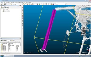
As part of the its Fast Track Webinar Series, Trimble will present a complimentary webinar on Wednesday, August 24, dedicated to uncovering the true "Scan to BIM" workflow. The one-hour presentation will cover the basic principles of processing a point cloud to create a deliverable that a contractor can use for project analysis.
 
The processes covered will include:

  •     registration of point clouds
  •     basic modeling functions
  •     export of point cloud data


Questions Trimble will address include:

  •     What type of deliverables should I be asking for?
  •     What do I do with the model and how do I integrate it (E57 format) into my existing 3D modeling suite?
  •     What are the options available today for incorporating scanning into my organization?
  •     What are the basics of how to utilize RealWorks to convert scan cloud data into a 3D model?
  •     How do I bring Realworks raw cloud data into NavisWorks?


Designed for contractors looking to implement laser scanning, this session will be a high level overview to give a better understanding of the processes necessary to take advantage of the power of laser scanning.
 
Registration is limited, so click here to sign-up today!

Tags: building constructions, 3D Scanning, building plans, 3D Scanner, BIM, contractors and laser scanning in northern Califor

Trimble Business Center Discounted Pricing

Posted by CSDS Blog on Wed, Aug 10, 2011 @ 08:24 AM

Trimble logoSpecial Offer: Trimble Business Center 2.5 Update

For a limited time, customers can now update to the latest version of Trimble Business Center for one low cost, regardless of the status of their Software Maintenance Agreement.The new version of Trimble Business Center includes the ability to: seamlessly exchange 3D scanning and imaging data with Trimble RealWorks, export directly to a GIS using Shapefile and Geodatabase formats, create stunning panoramic pictures from Trimble VX and S8 total stations, and to perform many other new functions. 

Until December 31st, 2011, customers can receive a $300 discount on an annual Software Maintenance Agreement, even if their Software Maintenance Agreement or initial warranty has expired. Any customer currently on Trimble Business Center 2.00 or higher whose Software Maintenance Agreement or initial warranty has lapsed for 90 days or more is eligible for this discount.

Why update? The new version of Trimble Business Center includes the ability to:

  • seamlessly exchange 3D scanning and imaging data with Trimble RealWorks
  • export directly to a GIS using Shapefile and Geodatabase formats
  • create stunning panoramic pictures from Trimble VX and S8 total stations
  • perform many other new functions.                                                                                                                                                                            

If you would like to take advantage of this special promotion, please email sales@csdsinc.com and we will have a representative from our Land Survey Division contact you directly.

Note: Customers with an active Software Maintenance Agreement or initial warranty in place are entitled to the 2.50 update at no extra charge. Customers with a Software Maintenance Agreement or initial warranty that has lapsed, but for fewer than 90 days, may renew for the normal price.

Tags: trimble, Trimble Business Center v2.5, land surveying, construction, land survey

Free BBQ & Educational Seminar on GeoExplorer 6000

Posted by CSDS Blog on Tue, Aug 09, 2011 @ 08:56 AM

geo6000rngpl resized 600Join California Surveying & Drafting Supply for a free two-hour educational/informational seminar to introduce the new Trimble GeoExplorer Series.
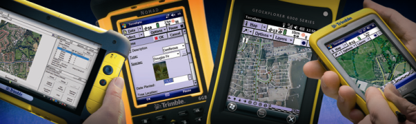
With the power and precision to get the job done, the Trimble GeoExplorer 6000 Series GPS and GLONASS handheld field computer delivers dramatic improvements in position availability and accuracy -- even in difficult GNSS environments. Don't miss this opportunity to come by and learn about the amazing features this new series of handhelds offers:

  • Trimble Floodlight technology
  • Built-in 5 megapixel camera
  • On-board 3.5 G modem
  • Large sunlight readable display
  • Field swappable battery

A BBQ lunch will be served at noon, followed by a 30-minute presentation on the GeoExplorer 6000. The afternoon will wrap-up with hands-on field demonstrations and a question and answer session.

There are three locations for your convienience: There is no charge for this seminar, but registration is required.  Registration forms can be found at the links above, or by contacting your local saleperson.

Tags: trimble, GPS technology, forestry GIS solutions, GeoExplorer 6000 Series, Trimble Floodlight Technology, Trimble Floodlight satellite reduction technology, high accuracy GIS data collection