CSDS' Blog

3D Laser Scanning Made Easy!

Posted by Lori Gandleman on Thu, Jan 12, 2012 @ 04:55 PM

Focus3D with Screen on resized 600If you've been looking to get into high-speed laser scanning but were intimidated by the learning curve and relatively high costs involved with this emerging technology, your wait is over. With the Faro Focus 3D laser scanner, scanning is as easy as 1-2-3...literally!

Unlike conventional scanners, the Faro Focus 3D does not require an external computer because the user interface is all on-board. Its compact size and intuitive control concept with touchscreen display allows users to point, shoot and export data in 3 simple steps, making it as easy to use as a digital camera. 

With the Faro Focus 3D, all set-up is fast and efficient - and no special targets are needed. In fact, printable black and white targets can be used for registration, eliminating the need for special targets typically required with conventional scanners. And, all point cloud data collected can be processed more easily into formats compatible with Revit, Navisworks, AutoCAD and other standard BIM and design applications.

Want to learn more? Attend a FREE hands-on seminar:

Find out why this affordable, precise and revolutionary simple scanner is gaining popularity among your peers by attending a free hands-on seminar at one of our three northern California locations.


Click me


Tags: 3D Scanning, Faro Focus 3D

FREE WEBINAR: Trimble RealWorks & The Deliverable Point Cloud

Posted by CSDS Blog on Wed, Aug 17, 2011 @ 11:31 AM

BIM Software Image
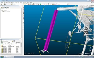
As part of the its Fast Track Webinar Series, Trimble will present a complimentary webinar on Wednesday, August 24, dedicated to uncovering the true "Scan to BIM" workflow. The one-hour presentation will cover the basic principles of processing a point cloud to create a deliverable that a contractor can use for project analysis.
 
The processes covered will include:

  •     registration of point clouds
  •     basic modeling functions
  •     export of point cloud data


Questions Trimble will address include:

  •     What type of deliverables should I be asking for?
  •     What do I do with the model and how do I integrate it (E57 format) into my existing 3D modeling suite?
  •     What are the options available today for incorporating scanning into my organization?
  •     What are the basics of how to utilize RealWorks to convert scan cloud data into a 3D model?
  •     How do I bring Realworks raw cloud data into NavisWorks?


Designed for contractors looking to implement laser scanning, this session will be a high level overview to give a better understanding of the processes necessary to take advantage of the power of laser scanning.
 
Registration is limited, so click here to sign-up today!

Tags: building constructions, 3D Scanning, building plans, 3D Scanner, BIM, contractors and laser scanning in northern Califor

Technology is changing the role of surveyors. Are you prepared to rise to the challenge?

Posted by CSDS Blog on Fri, Mar 11, 2011 @ 02:15 PM
Changes in technology are forcing land surveyors to adapt and rebrand themselves to manage the technological shift and take advantage of new job opportunities.  Are you prepared to rise to this challenge? Click on the link below to read Houston Neal's article "Automation of Surveying Creates Disruption and Opportunities" on the Software Advice blog and let us know how you feel about the changing role of surveyors.

 http://www.softwareadvice.com/articles/construction/automation-of-surveying-creates-disruption-and-opportunities-1022211/.

Changes in technology are forcing land surveyors to adapt and rebrand themselves to manage the technological shift and take advantage of new job opportunities.  Are you prepared to rise to this challenge? Click on the link below to read Houston Neal's article "Automation of Surveying Creates Disruption and Opportunities" and let us know how you feel about the changing role of surveyors.

 http://www.softwareadvice.com/articles/construction/automation-of-surveying-creates-disruption-and-opportunities-1022211/.

Tags: trimble, field software, 3D Scanning, 3D Scanner, land surveying, surveying, Trimble Access v1.8.0

Processing 3D Point Cloud Data Using Trimble Realworks v. 6.5

Posted by CSDS Blog on Tue, Mar 08, 2011 @ 11:22 AM

By utilizing spatial imaging solutions, land surveyors can now combine the precision of traditional point surveying with the compelling impact of images and scanning. Developed specifically to complement traditional surveying workflows, Trimble 3D laser scanners are designed to minimize your time to deliverable and expedite activities from field data collection through processing and deliverable creation.

If you are thinking about incorporating 3D laser scanning into your business and want to learn more, CSDS invites you to view this short video by Trimble certified trainer, Tom Cardenas entitled:

                                          Processing Data from a Trimble FX Scanner

The presentation will cover:

  • Setting Project Preferences in Realworks 6.5
  • Importing Control Coordinates
  • Importing Raw FX Data (TZS files)
  • Extracting Point Clouds from the TZS Files
  • Quickly & Easily Registering (stitching) Each Scan to create a complete point cloud of the scanned object

Tags: trimble, 3D Scanning, building plans, 3D Scanner, surveying, construction, new survey technology